Today is
the first day of Japanese Golden Week (April 29). So, for some of you planning
a casual hiking this week near downtown Tokyo or Yokohama, I tell you my
experience of walking Rokkoku Pass hiking course, aka, Miura Alps 三浦アルプス. The half of the route goes through 3 Citizen
Forests of Yokohama’s South Forest area. I thought my original ambition would
be complete if I conquer Rokkoku Pass route … Wrong. On April 15, the former
off-limit area of Kanazawa Forest, which is accessible from Rokkoku Pass route,
became open. I’ll report you when I visit there … the map of the Kanazawa
Citizen Forest 金沢市民の森 says there is a large pond in the Kanazawa
Forest. I must see it!
 |
This
way to a newly opened part
for the Kanazawa Citizen Forest |
 |
| NEXCO
showed this map at the mouth of the route. |
Anyway,
especially Kamakura side of the Rokkoku Pass course, about 3 hours of walk, is a
kind of introductory course for novice hikers. It is also popular among foreign
tourists as it goes through Kenchoji Temple 建長寺, Zuisenji Temple 瑞泉寺, and
Kamakura-gu 鎌倉宮. On the other hand, for the people in Kamakura, there is no reason to
climb steep hills to visit these places. Ancient flat roads connect the temples
for millennia, with public transportation (Enoden Bus 江ノ電バス) coming and going nowadays. Rather,
Rokkoku Pass hiking route is an ancient arterial road connecting Edo (Tokyo) and
Kamakura / Shonan area 湘南. By the 17th century Shonan became a major tourist
destination. For centuries many people have used Rokkoku Pass route for fun of
tourist attractions, i.e. ancient temples and shrines in Kamakura + Shonan Beach. I have added my share on this well-trodden path! Japanese love to call
anything for continuous popular trekking route ‘Alps,’ and hence the name, Miura
Alps. (Ha ha) The original entrance of Rokkoku Pass route started from Kanazawa
Bunko 金沢文庫 (yes, aka Shomyoji Temple Citizen Forest 称名寺市民の森). But
these days Shomyoji Temple surrounded by detached houses, supermarkets, and busy
National Route 16. So, when we begin our hiking these days, we normally start
from Keikyu Kanazawa Bunko Station 京急金沢文庫駅. From Kanazawa Bunko Station
to Kenchoji Temple, Kamakura-gu, or Zuisenji Temple, it is about 7 hours (leisurely
visiting historical temple edifices inclusive) of walk. The route would be
perfect for a sunny weekend hike very near from the downtown Tokyo.
 |
| Map of
Kamakura side for Rokkoku Pass at Kamakura-gu |
First,
we leave from the West Exit of Kanazawa Bunko Station. At the foot of steps
turning our eyes to the direction of Yokohama Station, we can see a pedestrian
road going along the fence running on the side of the railroad track. It is
already a part of the hiking course. Just walk along this way for about 5
minutes, and at the end of the pedestrian way there is a blue direction plate
saying “Rokkokutoge Hiking Trail, This Way.” “Toge” (pronounced tow-gue) means pass. Keep on going until
you find a small railroad crossing on the right, and another blue direction
plate of “The Trail, This Way” on the left. 30m or so from the crossing there is
an old signpost Shomyoji Temple built in 1839, practically hidden behind a
notice board for neighborhood association of the area. The original sign post
says “To the right for Hodogaya-juku 保土谷宿 and Edo 江戸. To the left is for
Kamakura.” The post was for tourists from Tokyo at that time. Nowadays, the
road to the left ends up with private houses. Thus, to Kamakura we take the
road to the right. Walk 5 minutes or so, on the right there are 3 Koshinzuka 庚申塚,
called “Koshin-toh of Tanitsu Village 谷津村の庚申塔.” Tanitsu is older name of
the area whose villagers built these structures in the 18-19th
centuries to ward off “evil spirits” entering in their community. As Koshin
structures are constructed once in every 60 years, they are a proof the
community here is existing for quite some time … Proceeding further, we are
greeted by another blue signpost showing the entrance to the trekking road. Behind the blue plate, there is a wooden plate
with beautiful Chinese characters showing us “Rokkokutoge Iriguchi” (六国峠入口 “Entrance
to Rokkoku Pass Hiking Trail”). Next to it is the beginning of a steep slope.
Let’s just dive in.
 |
| This
way from the West Exit of the station |
 |
| Blue
plate at the end of pedestrian road |
 |
| The
signpost at railway crossing |
 |
| er …
supposed to be an ancient signpost |
 |
| Koshinzuka |
 |
| “Rokkokutoge
Hiking Trail, This Way.” |
 |
| Wooden
version of signpost at the mouth of the slope |
 |
| The
beginning is like this. |
Unless
you know this area of Yokohama is a part of Miura Peninsula where its geology
is with very shallow top soil and hard-pan below, you may think the trekking
road here is paved. Of course not. The busy tourist route of wide width was
used for centuries which blew up the thin soil long ago. Now the area is heavily
developed for housing, and we can hear the sound in this seemingly mountainous
road of busy car noises, cheering voices of kids in nearby schools, and anything
from the ordinary residential life in Japan. From the course, we can see
houses, condos and supermarkets between the trees either side of the road. The route
hosts several educational posters for local kids to learn ecology of the
forest. After about 500m of climbing, we reach to the ruins of Nokendo 能見堂. This
place once had a small temple, Tekihitsuzan Jizohin Temple 擲筆山地蔵院. In the 1660s, Kuze Hirotsugu
久世大和守広之, a local bureaucrat for the
Edo government built a small strucutre which was a branch of Shiba ZojojiTemple 芝増上寺 in Tokyo (one of the family temples of Tokugawa Shogunate). In 1694 an
exiled (from Qing Dynasty) Chinese Buddhist monk, Tohkoh Shin’etsu 東皐心越, aka Shinetsu Zenji 心越禅師, visited the temple and
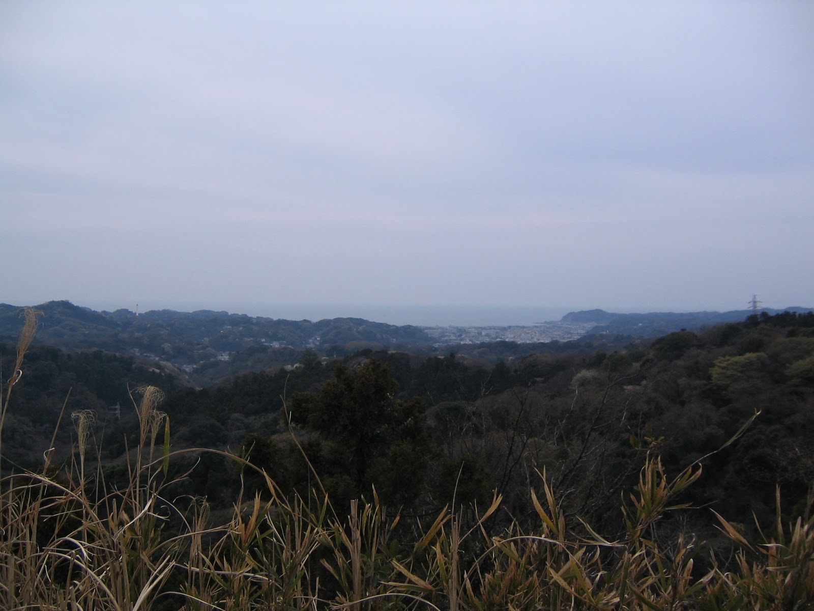
looked from here the scenery of Tokyo Bay. He was impressed, and wrote aChinese poem to praise the beauty of 8 phases of the vista. It became the
origin of the name Kanazawa Hakkei (金沢八景 “8 Sceneries of Kanazawa
Seaside”) town, next to Kanazawa Bunko. The place became famous thanks to the
poetry, and lots of literati visited, leaving poems, haikus, etc. Although the
sea was reclaimed a lot already by the 19th century, some seaside spots were
beautiful enough still in 1836 for Utagawa Hiroshige 歌川広重 to publish one of his masterpiece ukiyoe series, Kanazawa Hakkei. His ukiyoe became
wildly popular in Edo, and many tourists visited Nokendai to remember the
original scene
loved by the master Shin’etsu. Lots of visitors meant business chance. Until
the late 19th century, the place had a café in addition to the temple. But
after Tokugawa Shogunate period till the end of WWII, Japanese government kept
destroying the structures here and deforested the place for fuel … Now the ruin
is a kind of open space of several mounds with educational posters and stone
memorials erected by the City and local historical societies, commemorating the
heritage. Formerly artistic panorama is now the sea of
residential houses and supermarkets.
 |
| Old
route |
 |
| But
very near to the housing area |
 |
| Let’s
learn bugs’ life! |
 |
| Nokendai
with memorials |
 |
Nokendai
open space is accessible
in less than 10 minutes from the nearby housing
complex. |
 |
Beneath
the Nokendai,
there is this Fudoh-ike Pond 不動池. |
 |
| Public
Toilet near Fudoh-ike Pond |
From
Nokendo Ruins, follow the ridge way narrowly separated by the forest from the
residential area. Several signposts appear here and there saying “Kanazawa
Park, This Way.” Eventually, the trekking road bumps in to the
Yokohama-Yokosuka Toll Road with thunderous noise of cars. Keep on walking to
Kamariya Citizen Forest 釜利谷市民の森. From Nokendo Ruins to Kamariya Forest, it is
about 2k walk. Along the road in April, I found many Disporum sessile and
Arisaema urashima. When I first saw Arisaema urashima, I thought it should have
been brought in by somebody from his/her garden. Wrong. People say forests of
hard-pan from Miura Peninsula have lots of Arisaema urashima, native in the
area, but not in the North Forests of Yokohama … North and South Forests are
not so far away, even though … Caution! The seeds of Arisaema urashima is poisonous!
 |
| Please
excuse us to pass by your backyard … |
 |
Disporum
sessile and
Arisaema urashima
near Nokendo Ruins |
 |
Signposts
to Kamariya Citizen Forest
and Kanazawa Zoological Gardens / Botanical Park |
 |
| I
think this is still a continuation of ancient tourist route. |
 |
| Hello,
cars |
 |
| Kogane-dai
Plaza こがね台広場 of Kamariya Forest |
 |
| Toilet
for Kanazawa Park entrance. Fully equipped! |
 |
Nonohana-kan
ののはな館 in
Kanazawa Park,
with a tiny library-museum and café |
When
we reach to Kanazawa Park, simply cross the Valley of Ferns シダの谷 and
reach to G11 point that is at the side of Yoko-Yoko Road. The hiking route goes
for a while between the Yoko-Yoko road and the back of the Kanazawa Zoo. I’m
not sure if this part is the remnant of the ancient way … quite possibly the
route to Kamakura was disrupted by the construction of the giant tool road, and
here would be a new road, or a sub-route for the old tourists’ main road. Soon
we arrive at G12: to the right is the recently opened way to the center of the
Kanazawa Citizen Forest. To the left the road goes through the western edge of the
Kanazawa Park which is the south trekking route of Kanazawa Forest. The
standard Rokkoku Pass Hiking Route is to the left at G12. So, this time we
leave the occasion to visit the pond in Kanazawa Forest later, and we first
climb up, then slightly down to the pedestrian overpass 釜利谷陸橋 for Yoko-Yoko Road at G13. The
bridge is very large for a mountainous trekking road. It must be a work of
NEXCO. If you like, you can watch the stream of speeding cars for both
directions below here.
 |
| I had
a feeling the Valley of Ferns in April is dry. |
 |
| G11, "Toilet at Nonohana-kan, this way 300m" |
 |
| Along the Yoko-Yoko Road |
 |
| To the
left at G12 |
 |
| This
part of Kanazawa Park is hilly. |
 |
| The
view from G13 |
 |
| Very
wide bridge, |
 |
And a
rare white wisteria at the foot of the bridge.
I think it is wild. |
The
road from G13 to G16 has 2 crossings going down to the left for the residential
area, but the map says they are rarely used and not advisable to divert your
way. Let’s keep it safe and straight. Soon we are greeted with a signpost
showing a route to the right for Sekiya-oku View Point 関谷奥見晴台 within the NatureSanctuary, i.e. we have completed the road within the Kanazawa Citizen Forest
and entered the Yokohama Nature Sanctuary. Sekiya-oku View Point is a small
open space with picnic benches where we can see Tokyo Bay over there … If you
cross the View Point, you reach to the main ridge way of the Nature Sanctuary that
goes to the Visitor Center. From the Visitor Center, it’s a kind of semi-paved
way to return to the hiking course. We return to the original road from the
View Point and proceed to the south, to the direction of Kamakura Ten’en 鎌倉天園. Till
G17 we are in the territory of Nature Sanctuary, but from G17 to the south, the
road becomes narrower and more mountainous. The Yoko-Yoko Road is behind us and
the sound of the forest is far calmer. Phew. From G17, the border between
Yokohama and Kamakura is very near. The hiking route has a small open space on
the border for the visitors to say farewell to Yokohama. J
 |
| To
Sekiya-oku View Point |
 |
| Sekiya-oku
View Point |
 |
| … and
its view |
 |
The
trekking road within the Nature Sanctuary is wider.
We meet lots of trail
runners. |
 |
Hmmmmm
The scenery is very different from the shots in The Revenant.
Japan is definitely warmer than Alberta. |
 |
| G17
signpost shows the direction to Ten’en. |
 |
| You
see? The road is now narrower. |
 |
| The
open space sits on the border. |
From
the open space, for about 1K the hiking course runs Kamakura-side of the ridge
looking down the largest public cemetery in Yokohama, Yokohama Cemetery 横浜霊園. I’ve
met many fellow Yokohamans who said “You know, my dad bought his grave in Yokohama
Cemetery while he was OK. We buried him there, and complained for a while why
on earth he chose such a remote and inconvenient place to visit for his final
place. Then, we found the South Forests of Yokohama nearby. Now, we are weekend
hikers, paying a visit occasionally to dad’s. Ha ha.” Weeeeell, there is no
love like father’s, it is said. Around the time when we feel the cemetery is
behind, the road starts to climb up steeply. We reach to the famous café,
Ten’entoge-no-chaya 天園峠の茶屋, sitting on the border of 2 cities. A local
consensus is, have a lunch here; the matron allows us to bring our bento and
sit inside as long as we order something. The view to Sagami Bay from the
tables in the café is superb. Many recommends Oden (600 yen) … it’s difficult
to explain … a kind of pot-au-feu seasoned by soy sauce. The café also serves
drinks (beer, sake, soft drinks, H2O), ice cream, cup noodles, rice balls, etc.
and (my favorite) sweet red bean soup (500 yen). The price is a bit higher than
in convenience stores in town, but once we consider the cost of transportation
I don’t think it is expensive. (Oh, by the way, if it rains, they are closed,
normally.)
 |
| Lots
of wild hydrangea! |
 |
We
start to encounter boulders in the course.
It’s a very Kamakura-thing. |
 |
| And
the other side is a huge cemetery. |
 |
| Ten’entoge-no-chaya |
 |
Sweet
Red Bean Soup with Mochi rice cake
and cucumber pickle (in plum juice).
Yammy! |
 |
| Price
list |
 |
| The
view from the Café |
Roughly
speaking, from the Café to the north is to Kenchoji Temple建長寺, and to the south is to
Zuisenji Temple 瑞泉寺, and Kamakura-gu 鎌倉宮. (A map of Kamakura hiking
courses is here.) All the destinations are rapidly descending to about 20m
above sea level. Unless you plan to train yourself for trail running with the
cliffs after coming so far from Kanazawa Bunko Station, it would be wiser to
choose a point of the final destination out of 3 now. To Kamakura-gu, there are
2 routes: one is shown in Google Map, another not. Google Map course first
follows the same southern route to Zuisenji. We “fall down” a wall of huge rock
and the bottom to the right is the road shown in Google, and straight to
Zuisenji. There is another café on the left here who have a fulfilling menu for
tapas. (Though, they do not have a view.) This way to Kamakura-gu is quicker to
reach to the town, and the half the way is a paved road in a residential area.
So, if you are exhausted by now, this route would be the safest. The route not
shown in Google Map to Kamakura-gu first follows the same northward direction
to Kenchoji. From Ten’entoge-no-chaya to the north, take for about 5 minutes a
graveled wide path which actually enters the gate of Yokohama Country Club GolfCourse. Before the gate, there is a toilet so if you need to do the thing, this
is the place before reaching to the temples. By the way, the water here is not
potable, only to wash your hands. From the toilet, a narrower trekking road on
the left is separating from the graveled road for the golf course. It leads us
to the peak of Ohira-yama Mt. 大平山, the highest point (159.4m)
for the city of Kamakura. … er, the peak is in Kamakura, but 10cm from the peak
is Yokohama, so the place can be thought the highest point of the City of
Yokohama as well. Peak is at the top of another gigantic slippery rock, and
before you try mini-rock climbing there is a very wide sunny open space with a
view to Shonan Beach. A flaw: the west of the space is the back of the club
house + parking of the golf course separated by a meshed wall. I guess from the
top of the club house, those moneyed golfers could see Tokyo Bay and Sagami Bay
at once. Heck. Never mind, we can do (a sort of) this at the top of Mt. Ohira,
and this is the reason why this hiking course is called Rokkoku Pass Hiking
Route.
 |
From
the Café within 3 minutes,
the first chokepoint to the south.
About 5m high
slippery rock to drop down. |
 |
Before
this wall or a rock, there is another view point,
often occupied by hikers
having lunch. |
 |
A
signpost saying
“To the right, Kamakura-gu,
to the left, Zuisenji Temple” |
 |
| Toilet
near the Yokohama Country Club |
 |
To the
right is only for club members.
To the left is for us. |
 |
| Well,
the top of this golf club has certainly a view. |
 |
| You
can have a lunch here, too. |
 |
| A rock |
 |
| The
peak, Ohira-yama Mt. |
At the
moment, the side of the golf course needs mowing of Pleiboblastus chino Makino
for us to see clearly … even though, from the top of Ohira Mt., we can see
Tokyo Bay and (if you are lucky) Boso Peninsula beyond on the left, and Sagami
Bay + Hakone Mt, and Izu Peninsula on the right. Until 1871, the view from
Ohira Mt. contained the regions of Musashi 武蔵 (Tokyo, Kawasaki and
Yokohama), Awa 安房 + Kamiusa 上総 + Shimousa 下総 (Boso Peninsula), Sagami 相模 (around the Sagami Bay), and
Izu 伊豆 (Izu Peninsula); 6 regions. Ancient Japanese for “region” or
“prefecture” is “Kuni” or “Koku,” so Rokkoku means “6 regions” in old Japanese.
The peak of Ohira Mt. is the pass for tourist from Edo (Tokyo) to go by to Kamakura,
and people appreciated the vista to see 6 “Kuni” at once here. Hence the name
of “Rokkokutoge Hiking Course.” Soon after the point, the road tumbls down
another rocky cliff. We’ll be greeted by a series of huge boulders, and
probably artificially excavated petit valleys that would have been used for
centuries by the travelers. It is very-Kamakura scenery. Kamakura was the
capital of the national government reined by the worriers’ class for the first
time in Japanese history. Their fighting mentality chose this place surrounded
by extremely steep hills that are practically impossible for a large number of
enemies to mob the city at once. Rokkokutoge Hiking Route was a popular tourist
course, but the way in Kamakura side is almost always very narrow and difficult
to pass by one another. Very good defense.
 |
Er,
well, Tokyo Bay, a sort of,
beyond the Club House of the golf course. |
 |
| Vista
for Sagami Bay |
 |
Another
rock to go down …
at least the place does not roll,
so we trust Led Zeppelin
here …ah?? |
 |
This was
definitely dug by somebody
to make a way. |
 |
| Hmmmmmm |
 |
| Wow |
After
walking about 1.5k from the Café to the north, we meet a signpost showing the
way to Kenchoji Temple and Kakuonji Temple 覚園寺. To Kamakura-gu, choosing the
direction of Kakuonji, the road goes down rapidly to Kakuonji which is about
500m north of Kamakura-gu. On the way, there are coves some of which contains
crumbling statues of Buddha. I guess monks commuted this place ages ago for
their training of meditation … Kakuonji Temple is one of the oldest temple in
Kamakura, established in 1218, so that the route to Kakuonji from Ten’en must
be well-trodden for centuries. When we finally reach to the paved road within a
small residential area, on the right is Kakuonji. Kakuonji does not allow
unscheduled visitors to enter the premise. If you want to see the inside, you
have to join the organized tour by the monks. A tour starts at 10:00, 11:00,
12:00 (weekends only), 13:00, 14:00, and 15:00 from the entrance. Admission is
500 yen for an adult (200 yen for under 15, cash only). Passing Kakuonji, there
will be another Koshinzuka place, this time at least 5 of them, i.e. 300 years
of community existence. From here just follow the paved road to Kamakura-gu.
Kamakura-gu was once a temple called Tokoji 東光寺 that served as a prison for
Prince Morinaga (Moriyoshi) 護良親王 who was one of the
protagonists of political struggle during 1320-1330. In 1869 Emperor Meiji 明治天皇
ordered to change the ruins of Tokoji Temple into a shrine to commemorate the
Prince, which is now Kamakura-gu Shrine. Hm. Everything sounds a bit of high
blow, but actually, the festivals in Kamakura-gu are always very cozy neighborhood
affairs compared with those of the major tourist attractions like by Tsurugaoka-Hachiman-gu
鶴岡八幡宮, or Hasedera Temple 長谷寺. When there is no festival,
the place is calm space surrounded by the forest we’ve just come from. From
here to JR/Enoden Kamakura Station, it is the most comfortable to walk a narrow
alley way for about 20-30 minutes via Egara Tenjin Shrine 荏柄天神, Seisen Elementary School 清泉小学校,
Kamakura Elementary of Yokohama National University 横浜国大付属鎌倉小学校, and Tsurugaoka-Hachiman-gu.
 |
The
signpost at the crossing to Kenchoji, Zuisenji,
and Kakuonji / Kamakura-gu |
 |
| The
place of meditation |
 |
| Don’t
come this place if it rains … |
 |
| I
found this formidable Arisaema urashima near the exit of the hiking course. |
 |
| The
exit from the Hiking Course to Kamakura-gu |
 |
| Koshinzuka |
 |
| The
toilet in Kamakura-gu |
 |
Kamakura-gu
entrance: inside is no-photo zone.
We can visit the museum and the prison where
the Prince was held.
(Admission 300 yen, 150 yen for under 12, cash only) |
To
Zuisenji Temple, we take the route on the left after sloping down the steep
rock south of Ten’en Café. Comparing with the route to Kamakura-gu and Kenchoji
Temple, this route is relatively easy to walk. Sure, there still are large
boulders and slippery road of rocks, but they are fewer. The course first goes
through the forest of Hinoki cypress, then to the forest of evergreen
broad-leaved trees. As this is Kamakura, the road is really compacted due to
the usage of millennia, and there are several caves that must have been places
for Buddhism training. There are lots of signposts along the way to assure us
this road goes to Zuisenji, so don’t worry. From the Café to Zuisenji, it is
another 2k. When we actually arrive at Zuisenji Temple, we realize the place we
have been was the ridge way surrounding the site of Zuisenji. Zuisenji is a Zen
temple that was established in 1327 by the famous Zen master Musokokushi 夢窓国師 (夢窓疎石), whose disciples included the Emperor
and the Shogun of his time. Since then, many men of letters who contributed to
Japanese literature, including Nobel laureate Yasunari Kawabata 川端康成,
loved the meditative atmosphere of the premise enclosed by the forest. In 1970,
they excavated and restored a Zen garden at the back of the temple which is
said to be designed by Musokokushi … The garden gave me a deja-vu … the place
looked very similar to one of those sceneries I’ve met in India. Maybe
Musokokushi dreamed of visiting the places where Buddha originally meditated … By
the way, at the bottom of the valley, Kamakura-gu and the entrance of Zuisenji
is about 5 minutes’ walk, whose route shares the final 200m of the shortcut to
Kamakura-gu from Ten’en. From Zuisenji to Kamakura Station, going to
Kamakura-gu first would be the easiest.
 |
| Art,
isn’t it? |
 |
| Going
down to Zuisenji Temple |
 |
| The
course exits near Zuisenji. |
 |
Zuisenji
Temple
(Admission 200 yen, 100 yen for under 15, cash only) |
 |
| Zen
Garden |
 |
Within
the sanctuary … well,
not much different from where we came from, yeah. |
The
course descending to Kenchoji from Ten’en certainly has the best vista among
the 3 destinations, but there is a catch. To reach to Kenchoji exit of the
hiking course, we have to pay the admission (300 yen for adults, 100 for under
12, cash only) to the temple. The final part of the course goes through the
entire campus of Kenchoji Temple so that it would be reasonable … Anyway,
choose the direction of Kenchoji when we reach to the signpost for Kakuonji and
Kenchoji. The course is still going up for a while, including a petit
rock-climbing. We meet giant boulders here and there. The caves with crumbling
statues of Buddha appear. Then on the right, it is supposed to appear a stone
monument saying “The 50 best vista in Kanagawa Prefecture: The view from the
rock of Kamakura 10 Kings 鎌倉十王岩の展望.” I could not find it this April. That should
be a point directly above the main shrine of Tsurugaoka Hachimangu Shrine, and
we must have been able to see the straight Wakamiya Oji Street 若宮大路 from
Tsurugaoka Hachiman to Yuigahama Beach 由ヶ浜. (The scenery photo, here).
Hmmmm, next time, maybe. From this point to the entrance of Kenchoji, it’s only
about 5 minutes’ walk. We are greeted by the signpost saying “ Kenchoji This Way,
Meigetsuin Temple 明月院 This Way. Soon the Hanzobo 半僧坊 Entrance of Kenchoji Temple
appears, with the notice “You must pay admission to enter the premise.” OK, OK.
 |
| Blue
flowers are Lithospermum
zollingeri. |
 |
| Let’s clamber! |
 |
| The place for meditation … |
 |
I
think the view point should have been
somewhere around here … |
 |
| Kenchoji
this way |
 |
| Pay
the admission! |
 |
| Hanzobo
Entrance to Kenchoji Temple |
Kenchoji Temple is HDQ of Kenchoji School of Rinzai Sect for Zen Buddhism 臨済宗建長寺派,
established in 1253 by Chinese monk, Lanxi Daolong 蘭渓道隆. The Hanzobo place we entered from Rokkoku Pass Hiking
Course is a kind of shrine built in 1890 to be dedicated to the guardian of
Kenchoji Temple. Next to the entrance there is a view point where we can
appreciate the panoramic view of Sagami Bay, Mt.Fuji (if you are lucky) and the
entire ground for Kenchoji Temple below. From there, we go down the steep
stairs, pay the admission at Hanzobo, and proceed further down to the series of
buildings of the temple campus. Immediately after the Hanzobo, there are a
series of statue of Tengu goblins 天狗 along the stairs. Cute. At the
bottom of the valley, if you turn left, there is another temple building called
Kaishun’in 回春院. In a small cemetery attached to Kaishun’in, there is a grave of a film
director Nagisa Oshima 大島渚 who died 3 years ago. Very interestingly, Kenchoji’s building to
meditate called Hojo 方丈, is bigger than the Butsuden 仏殿 where the main statue of
Buddha is situated. i.e. This is the temple of Zen meditation, more than the
house of worship. We can have a mini meditation inside the Hojo where a cushion
of meditation is provided always. In the back of the admission ticket, it says
“Tenkazenrin 天下禅林,” i.e. “It is a place of education for anybody to
Zen.” Ah-ha. They have meditation lessons every Saturday from 17:00-18:00.
You’ll notice next to the main entrance of the temple there is a school. It is
Kamakura-gakuen Jr-Sr High 鎌倉学園 for boys, one of the best
prep-schools in Kanagawa Prefecture. In the afternoon, the boys in baseball and
soccer uniforms run in the campus of Kenchoji. Well, the tradition is going
strong. From Kenchoji Temple, we can just the follow the stream of people to
the nearby JR Kita-Kamakura Station 北鎌倉駅 whose entrance cut through the
campus of another HDQ Rinzai Zen Temple, Enkakuji 円覚寺.
 |
| View
from the Hanzobo Entrance of Kenchoji Temple |
 |
| Hanzobo |
 |
| A cute
boy |
 |
The
grave of Nagisa Oshima.
When I’ve been there, there was a can of Taiwan Beer
dedicated to the site.
An international admirer may have come here recently. |
 |
| Hojo |
 |
| The
cushions are rectangle in Hojo. |
 |
It is
folded in this way,
and we sit on the folded part in order to
avoid making our
foot numb after the meditation. |
 |
| Inside
of Hojo |
 |
Temple
Bell of Kenchoji,
a national treasure,
casted in 1255 with the inscription
chosen by Lanxi Daolong |
 |
| Admission
ticket |
 |
| April
is the month of peonies in Kenchoji. |
 |
| San’mon
(三門, the third Gate) of Kenchoji |
 |
I just
found this notice board of neighborhood associations
in front of Kita-Kamakura
Station.
The beautiful signature in Chinese character is done
by none other
than the Head of Enkakuji Temple. Wow. |
If you find a problem in Rokkokutoge Forests,
please make a contact with
Office for the Park Greeneries in the
South 南部公園緑地事務所
Yokohama Municipal Government
Creative Environment Policy Bureau 横浜市環境創造局
Phone: 045-831-8484 (I guess in
Japanese only)
FAX: 045-831-9389 (I hope there is
somebody who can read English …)
Kanagawa Prefecture Government Yokosuka-Miura
Region Center 神奈川県横須賀三浦地域県政総合センター
Phone: 046-823-0120 (I guess in Japanese only)


Damn you killed this. Awesome work. I been hiking through here for years. This by far is the most in-depth information I've ever come across. Thanks for doing it! A lot of work, I'm sure. Well done.
ReplyDeleteThank you! One additional info: during the first 3 days of New Year, coming to temples and shrines in Kamakura was a sort of never-ending rush hour commuting with Tokyo Metro, as millions visit these places. BUT, if you hike this course from Yokohama, your route ends at the back doors of Kenchoji, et al, which are not at all crowded. Actually, knowing locals prefer this way to visit Kamakura for January 1-3. … Yeah, unless we hike back to the mountain, it is inevitable to endure a packed crowd in train stations of Kamakura for return ... At least, half the itinerary is relaxing. Least bad, don’t you think?
ReplyDelete