In order to take care of afforested forests for water source, there is a cycle of jobs. Preparing the ground, planting seedlings, mowing, pruning, thinning … if the forest is for commercial logging, the final task is deforestation, then, the new cycle of ground preparation begins again. This week, I show you a bit of pruning for Japanese cypresses we’ve done recently. After our activity, I’ve felt a kind of “accomplishment” similar to a sense we have with a warm shower after a jog. Observing our job done gave me really a good satisfaction. It’s not smugness, believe me. Let me start telling you my pruning adventure to nurture the afforested forest for water source in the climate of Kanagawa Prefecture.

At the first stage before planting, the ground must be prepared. There may be a landslide, or deforestation by commercial logging. The space is cleared and the soil is to be plowed for baby trees to settle in. Additionally in Kanagawa prefecture it is a “MUST” these days to construct 2m high meshed barriers enclosing the vacant area in order to prevent the invasion of deer which love to devour baby trees for lunch. Then, we plant seedlings. Recently it is more common in Kanagawa’s public land to plant broad leaved trees after harvesting of coniferous trees, hoping to create quasi-natural forest of our climate. Since mountains of Kanagawa are steep, the baby trees are often planted at the corner of rectangle whose sides are shorter in ridge and valley sides than for the sides of slopes. Reason? The canopy of trees planted nearer to the ridge grows wider to the direction of valley, which would reduce sunshine for the leaves of trees placed to the next lower place. In order to prevent the effect, we often keep the distance between the seedlings to ridge-valley direction. If they are the babies of coniferous trees, the standard in Kanagawa is 3000 of them per 1ha. For the areas of more intensive commercial forestry in southern Japan, it’s more common to plant 6000-8000 seedlings in 1ha. 3000 “would be optimal here,” I’ve heard from the professionals. We mark the corners of rectangles, and dig a hole there deep enough for the roots of a seedling can be stored with about 0.5 inches of soil covering their basis. We next “do a circle” around the baby tree to tread down the ground to support the seedling standing. I love this process, as it’s like a dancing for babies to grow well. 😊 The planted seedlings are indicated by a bamboo cane tied to their fragile trunk for propping up. These sticks become a mark when we mow the field to avoid chopping them off accidentally.
 |
| The seedlings are planted this way in the mountains of Kanagawa. |
 |
| The
seedlings of broad leaved trees we’ve planted the other day. The meshed fence behind them is enclosing the afforestation area, protecting inside from deer lunch. |
 |
| First we dig a hole deep enough to cover the roots of a seedling. The excavated soil is temporary stored in the upper side of the hole, and gently moved back to the hole with the seedling. |
 |
| Stomp-dancing
around the seedling. We gently grab the baby tree and pull it up slightly while we do a circle around it. |
 |
| Loosely
tie the seedling to a bamboo cane to support it standing, and as a mark. |
Ideally, mowing for an afforested area is done at least once a year during summer for the first 5 years of baby trees. During this period, the seedlings are still small and the weeds dominate the place in Kanagawa’s summer, which could prevent the toddler trees to receive enough sunshine for photosynthesis. For coniferous seedlings, once they become tall enough to escape from the overpowering grass, it is the time of the first pruning. To create straight and long logs for human consumption out of Japanese cedars and cypresses, it is important for a tree to have enough time, 2-3 years, covering sections by epidermis after pruning especially near the root. (Nearer the root, fatter the trunk, so that pretty lower bottom of a tree can provide more substantial logs. Got it?) Moreover, the dead boughs could create a huge hole on a tree’s trunk when we neglect the care for them. The crucks created by dried out branches attract pests and viruses, such as Cerambycidae, that will kill the tree eventually. It is important pruning cedars and cypresses regularly for at least their first 20 years, starting from their 5th-8th year.
 |
| The
no-pollen cedars of their 5th year summer. The ground is completely covered with grass and shrubs but now they are tall enough to receive sunshine by themselves. The mowing of the place is completed this year, and probably next year or so we will do the first pruning. In Japanese forestry lingo, the first pruning is called Suso-harai 裾払い, “rear foot sweep” that is from sumo technique. |
The traditional theory of afforestation in Japan is, cypresses are for drier place so that it is standard during your hike finding them near ridge after a cedar forest. (People do not follow standard always, of course. 😉) The point to differentiate cedars and cypresses is ground litter. Japanese cedars shed the old branches by themselves. When you find branches of coniferous trees on the ground in Kanagawa’s mountain, the trees around you are cedars. Often they are along the mountain stream, or near the valley. When humans harvest the tree in desired size, their natural discarding could be too late for sections to be wrapped completely with the outer skin. Or, the left-out broken boughs could be an entry way for diseases. Thus, pruning. On the other hand, Japanese cypresses do not drop their bough even when the branches are desiccated. Cypresses renew their tiny 1-2mm leaves during fall to winter, leaving the boughs sticking out of the trunk. The lifespan of leaves of Japanese cypresses is about 6 years. After summer their 6th year leaves fall off from the branches and cover the ground underneath.
 |
| The
stems separated from the fallen branches of Japanese cedars |
 |
| Trekking
road in Mt. Oyama 大山 running in the Japanese cypress forest. Could you see the difference with the above photo? |
With these characteristics in mind, pruning is important especially for the health of coniferous forests. A forest of cedars et al without proper pruning is a dark place. Being it cedars or cypresses, the withered boughs and branches block the sunshine reaching to the forest floor. It becomes difficult for undergrowth to take hold when only the tree top receives enough power of sun. In such forests, the trees grow lanky with insufficient development of roots. The slope becomes vulnerable for soil erosion. For example, decay of fallen cypress leaves is VERY slow. In a dark cypress forest, it’s like walking on leaf-confetti without much hurdle of ground-growths. Furthermore, as you may expect, the cypress leaves are too small to stop water flow when it pours over a steep slope. There is this academic paper 林試研報 about substantial soil erosion in cypress forests. It fares better for forests of cedars without pruning whose ground is covered by shriveled branches scattered all over. But their effect is not much for soil protection. In contrast, proper pruning create space within a forest for sun light reaching to the ground. With rain and sun, the dormant seeds of grass, shrubs, and trees will sprout. They eventually protect the soil and forest to be washed away by storms. The trees grow with deep roots and store water underneath. Pruning is vital for maintaining water source forests in Kanagawa.
 |
| The
cedar forest in the northeast slope of Mt. Oyama. I think Atsugi City does a good job for keeping the coniferous forest by pruning and thinning. The sun light comes in here, but still the undergrowth is limited at best. In this photo, we can identify lots of retaining walls made of thinned logs to prevent soil erosion. Creating hierarchical structure in a forest is really difficult … |
The height of the pruning depends on the objective of the usage of trees. When we plan to harvest a coniferous log for a pillar of standard Japanese house, we prune off branches and boughs sticking out the lower 6-7m part of a tree until its 20-25th year. For a material suitable for repairs of gigantic temples in Nara or Kyoto, people nurture a cypress for decades or centuries by pruning the lower boughs nearer to withered branches deprived of enough sunshine by the leafs spreading above them. Kanagawa prefectural government does not recommend volunteers pruning with ladders at the height higher than 2m. So, we tackle with the branches within our reach. For creating a beautiful trunk of a tree, best pruning seasons are October-December and March. During dead-winter, trees dramatically reduce their water intake from the ground and their body becomes hard enough to make the operation difficult. When trees drink a lot during late spring to early summer, their vascular bundle is expanded with lots of liquids running inside. When a part of the system of bundle is terminated abruptly in the middle, which is pruning, the vascular organ is exposed suddenly to the outer world with its mouth wide open. For a tree epidermis, it’s difficult to cover the large wound completely. The tree will have a hole under the bark at best. Otherwise, the trunk keeps a cavity, not good for health of a tree or housing material.
 |
| This
is one way of reaching to the higher branches. |
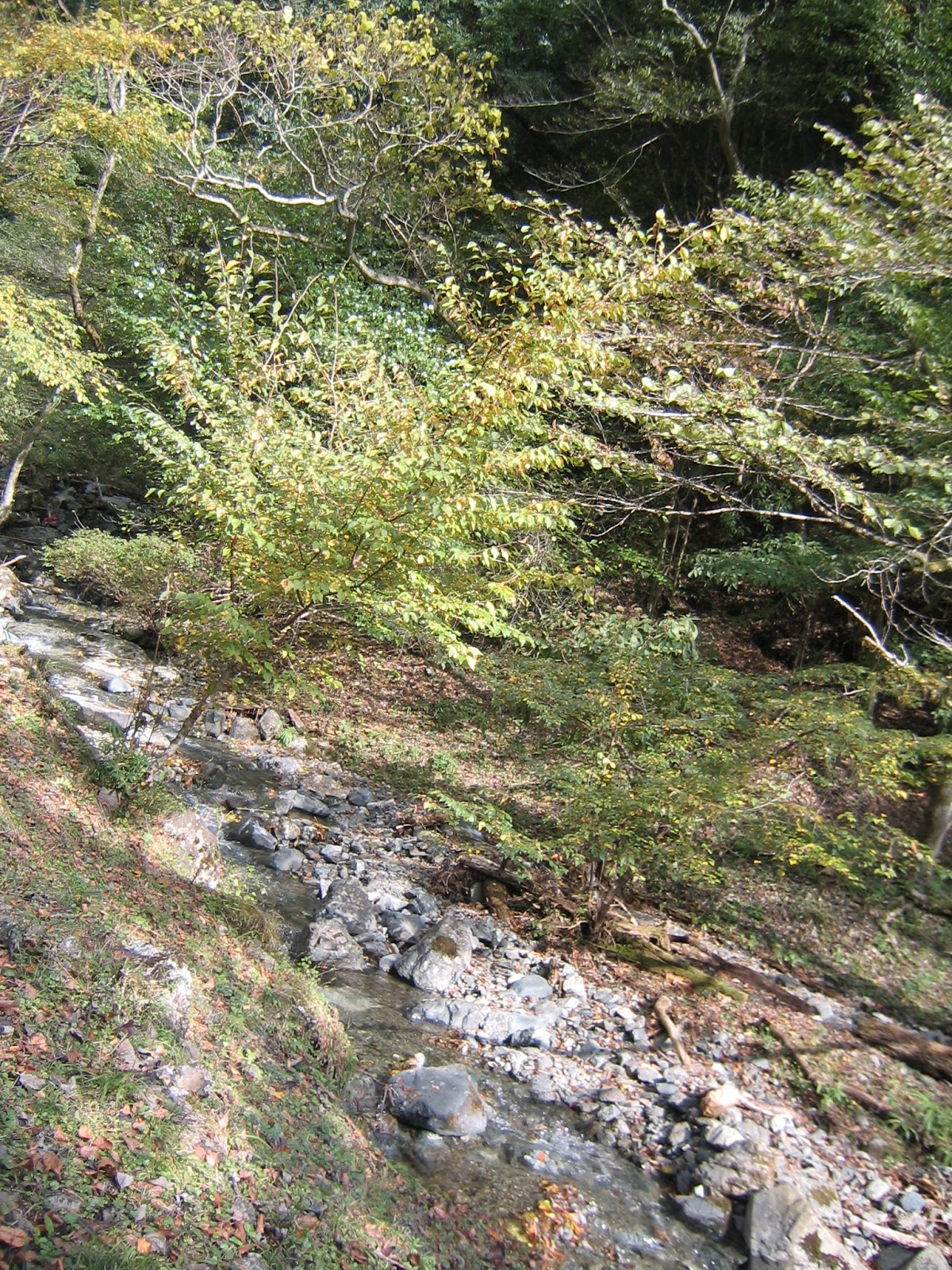
One weekend of this November, we entered a public forest located in the steep somma of volcanic Mt. Hakone 箱根火山. The place is a water source for Sakawa River 酒匂川 where many parts were afforested by coniferous trees decades ago. We forest instructor trainees have come this area several times as a part of the curriculum. Due to very rainy autumn this year, there were mini-landslides here and there in the area. I noticed several mini-ponds off the mountain stream where a couple of large cedar trees stood in a pool. The waterway had come that far during last storms … Our instructors told us due to 2 consecutive typhoons in October, there occurred numerous mini-land failures, although they did not triggered disaster downstream. Now the prefecture is busy in restoration works for the stability of the collapsed hills. The forest we pruned away this time was populated by 14 years’ old Japanese cypresses. They are still young with 20cm or so diameter. I noticed they preserved their withered branches at very lower part of their trunk. … They could not have their 5 years’ old pruning … the branches and boughs congested the forest. Inevitably, the entire place was very dark despite of a fine fall Sunday. Not much undergrowth was found except sasa bamboos whose roots expand horizontally over the shallow depth of the soil. I a kind of understood the reason of mini-slides in the area.
 |
| Could you figure out a mini-land slide over there? |
 |
| Lots
of dead branches are sticking out from the lower trunk of young cypresses. Although it was a windy day, not much air stream penetrated into the maze of tree boughs. |
Our task was to prune off the branches, and mow sasa bamboos to make space for more deep rooted vegetation growing with sunshine. The forest expands over very steep slope which makes pruning the branches sticking to the direction of ridge way easy, but I had hard times to deal with those spreading to the valley side. I, a short Japanese woman, cannot reach them from the front … Properly done, pruned-off part will leave a round cut end surrounded by branch seat which is a part of the trunk. Cutting into the branch seat damages epidermis that would cover the cut end otherwise. I could manage preserving branch seat, but my cut end looked oblong when I had to reach to a valley-side branch from the ridge way direction. Moreover, the young cypresses were surrounded 3-4m long sasa bamboos poking from their roots. Although the bamboos were leggy at about 1cm in diameter (as this place does not have enough sunlight), they block the access to a tree. Worse, they could make the slope more slippery, and our movement around a cypress became more dangerous. “Woops. You have not sawed the bough straight.” “If you find the branch large, first provisionally cut it about 10cm from the branch seat, and then prune it away completely at the mouth of branch seat.” My seniors advised me. Hm. I found the 2-step approach worked well. Doing mowing and pruning at once for each tree on a steep slippery slope required patience and concentration. That was a very meditative task ...
 |
| This
poor cypress was surrounded by sasa bamboos and kept its lower twigs poking out all over. It would be a candidate for a thinning … but today, we come here for pruning! |
 |
| This
is a good example of proper pruning for a coniferous tree (; the photo was taken in cedar forest in another occasion). Could you see the cut end is round? |
 |
| I
managed to do proper pruning this side … and the other side is remaining … |
Within 3 hours, roughly 80 volunteers of us pruned off the 1.6ha of young cypress forest. From the below, we could see the ground now receiving more sunshine, and the chilly autumn air started to flow among the trees. I hope the forest does not have torrential rain any more this year, but only drizzling or snow. If so, I imagined, early next spring when snow starts to melt slowly, spring ephemeral with enough sun-shine could show their head out of the ground, and start doing their job of stabilizing the soil of cypress forest. By and by, the water stored beneath the cypresses will join Sakawa River and come to Yokohama safely … I felt an accomplishment of our job. It might be self-satisfaction, but there is a scientific logic connecting pruning in the forest of deep-mountain and safe drinking water in a megalopolis. Calling our feeling “smug” could be very cynical and smug, I guess.
 |
| We
mowed only sasa bamboos and left shrubs, hoping for multilayered plant structure to materialize in the forest … |
 |
| The sun light is coming in now! |

Kanagawa
Water Source Authority
1194
Yasashi-cho, Asahi-ku, Yokohama, 241-8525
Phone:
045-363-1111