 |
| Deer! |
So, on that morning, we met at
Yaga Station 谷峨駅 of JR Tokai Gotemba Line 御殿場線. First, we go down a bit from the station, and
turn right to cross a pedestrian overpass across National Route 246. In front
of us, we can observe busy Tsuburano Tunnels 都夫良野トンネル for Tomei Express Way 東名高速. To the
north of #246, there is an expansion of rice paddies that were dry during
winter. Across the paddies, one paved way is going to a suspension bridge
leading to the foot of the hills. Cross that, and turn left. Follow this
commuter road for about 300m to turn right at the first corner. The paved way
is serving the community on the foot of Mt. Oonoyama 大野山. We can either take this road to reach to the
point of Yoritomo Cherry Tree 頼朝桜, or
another trekking route for a shortcut to the tree. Needless to say, we take
hikers’ course that was a quiet mountain road without much snow yet. For about
one hour we went up slowly to the Cherry Tree point.
 |
| Coming
from Yaga Station, turn right here. The long red bridge over there is Tomei Express Way. |
 |
| The
flyover comes down here. We turn left to take the road beyond that pillar on the left. |
 |
| It leads us to these steps to … |
 |
| the
paved straight road. I guess from spring to fall, both sides are full of rice. |
 |
| In the
middle of the straight way, there is this sign to Mt. Oonoyama. |
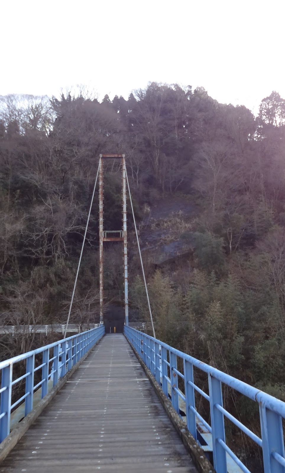 |
| Eventually, we meet with the suspension bridge. Let’s cross it, and turn left over there. |
 |
| The
bridge is over Kawachi River 河内川 from Lake Tanzawa 丹沢湖. The water reaches to Sakawa River 酒匂川, and then to Yokohama … |
 |
| The
road from the bridge is a paved community road. Proceed ahead … and … |
 |
| we go to the right at this point with ... |
 |
| This sign post saying “Turn right here to Mt. Oonoyama.” |
 |
| The
route gains the altitude rapidly from here. It is a community road for residents and cars are running here. Please be cautious. By the way, that red girder over our head is Tomei Express Way. |
 |
| Then,
on our left, there is this narrow road which is a short-cut to Yoritomo Cherry Tree. Don’t miss it! |
 |
| Yesterday’s snow … |
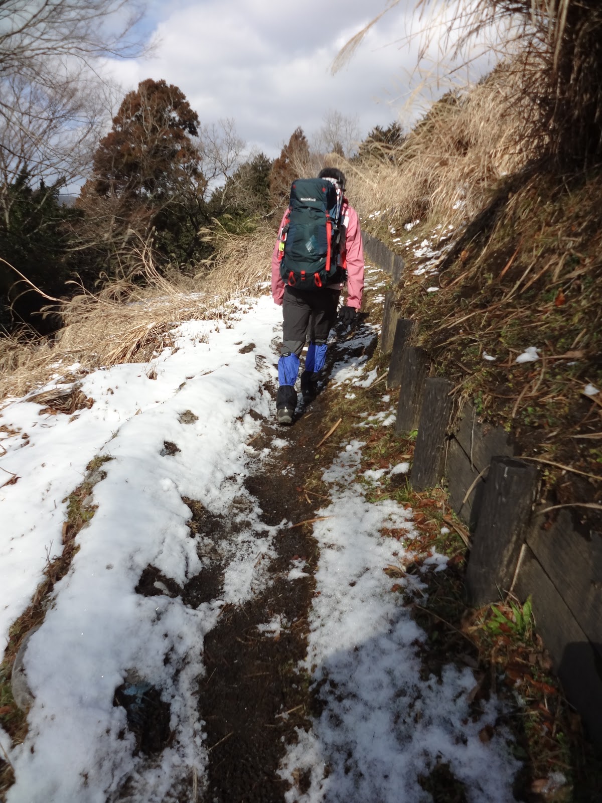 |
| As the
ground was not trodden down, the path was not much frozen. We were lucky. |
 |
| Though,
the road soon became like this. As it was a fine day at the foothill of the mountain, the snow piled up on the tree canopy melted and showered down over our head. That was a thrilling experience! |
 |
| The
final approach to Yoritomo Cherry Tree is steps that can be slippery when it’s frozen. Careful! |
 |
| The
top of the steps is a junction with the paved road for cars we separated below. |
 |
| Yoritomo Cherry Tree. |
 |
| The place also has a tourist map around Mt. Oonoyama. |
Legend says when young Minamoto-no Yoritomo 源頼朝, the founder of Kamakura Shogunate Government 鎌倉幕府, came here to escape from the assassins, he took a rest and left his walking pole made of cherry tree. It’s believed the pole stroke roots into the soil, and in hundreds years’ time became a large tree. The “original” tree was hit by a thunder about 200 years ago, and the current one is from a tiller of the root. I guess now (at the end of March), the tree is blossoming profusely. When we went there, it was surrounded by fresh snow ... (which means it had a perfect preparation to flower coming spring). The trekking road became the real snow road. From Yoritomo Cherry Tree, we can observe the very gentle peak of Mt. Oonoyama. Let’s proceed with the paved road to the direction of the summit a bit. On your right, we can find a log cabin which is public toilets. From this toilet point, a road on the right is diverting from the paved way. It is another shortcut to the top of Mt. Oonoyama. Enter there, and the route slowly gains altitude within the forest. At that time, the sky was transparent blue with warm sun shine, and small snow bombs were coming down over our head. Snow on the canopy was melting. It seemed us not many took this route before us after the snow fall. The soft white pile was not deep thanks to the tree canopy. It was a relaxing walk. For about 15 minutes or so, we meet once again with the paved car road we departed at the toilet. This time there is a small gazebo where we can take a rest.
 |
| The toilet and an entrance to the trekking road. |
 |
| Road
with fresh snow. I warn you, if it was not that fresh, the place definitely demands crampons. |
 |
| The crossing with a gazebo where … |
 |
| the
local landlord of Minami-ashigara City 南足柄市, Mr. Yamazaki (whom we forest instructors know), opens a small unmanned shop to sell the produce from his farm. They are actually delicious. Please pay honestly if you purchase something here, and help us to maintain our tradition of unmanned shop. |
From here for about 30 minutes, the route is the steepest in today’s itinerary. After the gazebo, the route enters an area surrounded by protective mesh against deer. Inside is of still young afforested trees. As we proceed, the view from the slope becomes more and more spectacular. During our expedition, the clouds started to cover the sky at this point, and to the west we could only figure out relatively flat expansion beyond Tanzawa mountains. That was a foothill of Mt. Fuji. If the weather is fine, you must be able to admire the entire beauty of the highest peak of Japan, with sparkling Lake Yamanakako … Caution. As the view is wide-open, you might be tempted to deviate from the defined trekking road. Please, DON’T. (1) treading the non-road kills off the small ecosystem below your footsteps. The area is recovering from the munching of overpopulated deer, and thus ecologically unstable. Please help us to restore the fragile environment. (2) OK you deviate from the road in Tanzawa, and soon you could fall off from a steep cliff even if you are in gentle-looking Oonoyama, especially when the ground is covered with snow. Please be sensible, and save your life. About at ASL 700m, the hiking road becomes flat which means we have almost reached to the wide expanse over the top of Mt. Oonoyama. The route is now demarcated by well-constructed barriers which are separating trekking road from the ranch. About 10 minutes stroll along the flat, but freshly snow-covered way, we arrived at the peak of Mt. Oonoyama, ASL 722.8m. To the south, we can observe cities of Shonan Beach 湘南海岸, and Sagami Bay 相模湾. To the east, we could meet with the highest peaks of Tanzawa mountains 丹沢, including Mt. Hinokiboramaru 檜洞丸 (ASL 1601m) and Mt. Hirugatake 蛭ヶ岳 (ASL 1672m). To the west is Mt. Fuji. The place is one of the 100 best viewing spots for Mt. Fuji in Kanto Region 関東地方.
 |
| Entering
in the protected area. In Tanzawa, there are lots of such protected areas secluded by wire meshes against deer. When we enter, the last person must close the gate for sure to make facility the most effective. Please help protect our delicate ecosystem. |
 |
| It’s
newly afforested area. If weather had been fine, over there should have been Mt. Fuji … |
 |
| There
were lots of footsteps of animals on fresh snow. I think they are of a fox. |
 |
| In the
middle of the route, there is a point saying “The altitude here (ASL 634m) is the same as at the top of the Tokyo Sky Tree.” Hmmmmmmmmmm, that’s very easy description to “feel the altitude.” |
 |
| When
you are surrounded by grass fields, it’s a sign your climbing to Mt. Oonoyama is almost over. |
 |
| The route becomes along the well-maintained barrier for the ranch. |
 |
| This is to the direction of Hakone 箱根 from the ranch. |
 |
| The top of Mt. Oonoyama! |
 |
| From
the top of Mt. Oonoyama. Down there, we can find Lake Tanzawa. Beyond that is supposed to be Mt. Fuji. |
 |
| Ditto for Mt. Hirugatake … |
The peak
of Oonoyama has 2 toilets. When we proceed further to the east from the top of
the mountain, the second toilet is in front of the parking lots, which are at a
crossing of 4 roads. One road is where we come from, the second is obviously
for cars, the third on the left is supposed to going down to Lake Tanzawa that
is now closed due to landslides. The forth running to the same direction from
where we came is the hiking route. First, it descends rapidly with long steps.
Later at the foot of the mountain, we talked we may have used crampons there …
at that time we didn’t, thanks to the fresh snow. We were simply lucky. Please
be conservative for your safety and wear your gear if you come down from
Oonoyama covered with snow. The steps go into the forest of afforested coniferous
trees first, and then of broad leaved trees probably used for charcoal making
before. In less than 1 hour of going down, there is a small sign showing on the
right there is a small temple of Kṣitigarbha 地蔵岩. We did a bit of diversion (of less than 20m),
and found a hut protecting a stone image of Kṣitigarbha. I learned it was a
place to pray for miscarried babies … in such a deep mountain. I imagined
mothers who came this far to cry. The mountain can swallow human torments and
stand still for millions of years …
 |
| The
beige structure on the left is the toilet we first encounter at the top of the mountain. |
 |
| To the left in this photo is the second toilet. |
 |
| The
crossing has lots of board explaining the route. Let’s check them. |
 |
| This way! |
 |
| The long steps. Thank god, no one was hurt … |
 |
| We proceeded along the snow-covered road in the coniferous forest. |
 |
| When
we entered in the forest of broad leaved trees, the snow was almost gone. |
 |
| The mini-temple of Kṣitigarbha |
Walking further down from a mini-temple, we meet with a small paved community road, which means we have completed our hike in Mt. Oonoyama and arrived at Kyowa community 共和地区 of Yamakita Town 山北町. Kyowa in Japanese means “Republican.” Wow. Among locals, the place is called as “Tibet of Kanagawa,” but I think there are lots of other places that may deserve more the designation, like the area around Lake Tanzawa or Doshi River 道志川. With the name “Republican” and the academic past of Yamakita, it might be interesting to do a research about the local history of the area. Anyway, this is the community the young ranchers I mentioned last week moved in 2 years ago to revive the ranch at the top of the mountain. Further down, there is Kyowa Elementary School 共和小学校 which ended its 137 years of history in 2011. Now the place is HDQ of NPO Kyowa Forest 共和のもり. They engage in the revitalization of mountainous community. The NPO organizes tourism events, like kimchee making from local Chinese cabbages every December. If you are interested in what’s going on in Kyowa community, you can check it here.
 |
| Coming
down from the mini-temple, the final stretch is these steps which lead us to |
 |
| the community road. |
 |
| As it
is a community road, it’s better to follow the direction indicating to Yamakita Station. Otherwise, you could go around the village in circles. |
 |
| Kyowa
community has a unique festival called Omineiri 山北のお峰入り held
once in every 5 years. The ritual has the designation of National Important Intangible Folk Cultural Propert 国指定重要無形民俗文化財. It is said that its origin was in the 14th century and the village presided it for every 10 to 20 years before. The current format was taken from the 1960s. The most recent event was held in October last year. (Huh, so we have to wait another 5 years!) The festival has a heavy involvement of Yamabushi priests 山伏 who sing and dance several formalized program together with the villagers for a whole day of the festival. This is a warehouse near Kyowa Elementary to keep the tools for the festival. |
 |
| Kyowa
Elementary. During summer, they open café here. |
 |
| Kyowa community |
 |
| At the
mouth of Kyowa community, there is a terminal bus stop named Oonoyama Tozan-guchi 大野山登山口 (“the entrance to Mt. Oonoyamaa hiking route”). The service is only for weekends of spring and autumn to Odakyu Shin-Matsuda Station 小田急新松田駅. In any case, it’s just 30 minutes’ walk from here to Yamakita Station. |
 |
| Before
arriving at the crossing with Route #246, there is this Koshinto statue 庚申塔 dated for the 18th century. This is an old community road. |
 |
| Down
there is Route 246. To Yamakita Station, go to the left. |
From Kyowa area it’s about half an hour walk within Yamakita Town to JR Yamakita Station 山北駅. Our last itinerary was Sakurano-yu Spa さくらの湯 that is in the 3rd floor of a pink building next to the Yamakita Station. This spa is popular among trail-runners for their weekend training between Yamakita Station and Ashigara Pass 足柄峠 in the Manyo Park 万葉公園 (; we visited there last year, remember?). The spa has nice Jacuzzis which strategically position jet-points for massaging muscles used for running, and hiking. J The place also has open-air spa area. The facility is run by Yamakita Town, and the price is fairly reasonable. I do recommend you to have a try. After drinking in freezing snow field, your body will surely be melted in Jacuzzi …
 |
| The entrance to Sakurano-yu Spa |
If you find environmental problems in
Mt. Oonoyama, please make a contact to
657 Nanasawa, Atsugi City, 243-0121 〒243-0121 厚木市七沢657
Phone: 046-248-0323
You can send an
enquiry to them by clicking the bottom line of their homepage at http://www.pref.kanagawa.jp/div/1644/
For more general enquiry
about tourism in the area, the contact address is
Office of Policy Planning,
Yamakita Town 山北町役場企画政策課 企画班
Phone: 0465-75-1122, FAX: 0465-75-3660
You can send an
enquiry to them from here.
